INTRODUCTION
Surveying is a mathematical science used to determine and delineate the form, extent, and position of features on or beneath the surface of the Earth for control purposes—that is, for aligning land and construction boundaries, and for providing checks of construction dimensions. Land boundaries are set or measured for accurate description; the topography of landforms and natural or artificial objects are depicted on maps; and major construction and civil engineering works such as dams, bridges, railways, and roads are controlled by surveying methods. The measurements of a survey are linear or angular, and principles of geometry and trigonometry are usually applied. Surveying , simply put, is the science of geometrical and trigonometrical measurements taken above, on or beneath the surface of the Earth. Surveyors are therefore alignment experts.
In relation to dredging, however, Surveying is the science of establishing control points for establishment of channels, canals, underwater structures, underwater mining areas and determination of seabed and land topography.
Dredging on the other hand is simply excavation of underwater soil, rocks and mineral resources for various purposes. Dredging projects are therefore carried out to;
- Open up & deepen channels for navigation
- Strengthen beaches by nourishment
- Create artificial islands for deep water ports, tourism etc.
- Stockpile Sand for construction works
- Reclaim Swampy terrain for residential, industrial or agricultural purposes.
- Excavate underwater trenches for utility lines
- Mine underwater minerals.
In each of the dredging projects mentioned above, the need for survey operations cannot be emphasized enough. Some of these surveying operations are common to these dredging components. I will however do justice to this paper by highlighting each survey operation and its relevance in various types of dredging projects. This, I believe will throw more light into the rather dark tunnel of survey trivialization in the dredging industry in Nigeria.
HYDROGRAPHIC SURVEYS
The surveying and mapping of seas, rivers, harbours, or lake bottoms to ensure safe navigation. Depths are done by hand soundings located by observations to or from control points onshore. Echo soundings with simultaneous radar-type location of the sounding vessel also permit rapid and exact charting. Farther out from the shore, less accuracy of location results; Loran devices are used for this purpose, and Satellite-
Navigation devices are also used for fairly accurate offshore positioning of vessels furnished with modern equipment. Opening up of new navigation routes require production of Hydrographic Charts covering the entire navigable route. Such charts will depict the length & width of the channel, the depth at various points for determination of both shallow and deep areas, position of navigation aids like bouys, light houses etc. this is an essential tool for planning and implementation of dredging projects particularly in capital and maintenance dredging of ports & harbours.
LAND SURVEYS
Land surveys are made to establish boundaries of land areas by setting corner markers or monuments, to ascertain coordinates of these corners, and to obtain boundary and area information required for record-deed descriptions and for plotting areas of property. Property surveys are accomplished with a degree of precision depending on the value of the land involved, and permanent visible and recoverable monuments are set at the corners. These markers are desirable for public record and to ensure correct title for the rightful owner of the land. In addition to surveying techniques, land surveyors must also be knowledgeable in property law.
Land survey operations are carried out in every dredging project that has the land component. Boundaries and areas of land to be used as dump sites, reclamation sites ,road networks in swampy terrain etc must be marked out on the ground and mapped. In stockpiling precisely, the need to know the quantity of sand that such site can contain is a factor for negotiations with landlords as well as the cost of dredging where quantity to be dredged is a factor for pricing.
TOPOGRAPHIC SURVEYS
Topographic surveys are three-dimensional; they employ the techniques of plane surveying and other special techniques to establish both horizontal and vertical control. The relief or configuration of the terrain and the natural or artificial features are located by measurement and depicted on a flat sheet to form a topographic map. Contour lines, connecting points of the same elevation, are used to portray elevations at any one of various intervals measured in metres or feet.
Much topographic mapping is done by means of aerial photogrammetry, which uses stereoscopic pairs of photographs taken by aerial surveys and, more recently, from artificial Earth satellite. Horizontal and vertical ground surveys must appear in the photographs. These photos are then reconstituted into stereo models for drafting true-scale maps. Precise cameras are required; and precision-mapping equipment is used to depict natural and artificial objects in true position and to show true elevations for all points in the mapped area. Elevations on topographic maps are shown chiefly by use of superimposed contour lines, connecting points of equal evaluation, to give a readable picture of the terrain.
In dredging projects like beach nourishment, Pre and post dredge topographical Survey of the beach to determine the rate of erosion, the height of fill and quantity needed and eventually pumped to nourish the beach, must be carried out.
In stockpiling and land reclamation jobs. It is of utmost importance that Pre and Post Topographic Survey of the proposed sand dump and reclamation site be conducted as these data are used for computation of quantity of material dredged, which in turn serves as the basis for computing cost of dredging. Expected heights of fill at these sites are pegged out on the ground and are also used to arrive at targeted quantities. Seabed topography is also an essential database for determination of shallow areas that need to be dredged.
ENGINEERING AND CONSTRUCTION SURVEYS
Engineering surveys establish control points by traverse, baseline, or other methods to obtain information required for engineering designs and to set out construction from design drawings by use of these control points. Topographic surveys, and the maps produced by them, provide horizontal location information and elevations needed for the design of structures such as buildings, dams, canals, roads, bridges, power lines, and sewers. Using the engineering designs these works are then laid out from the same control points used in the original engineering surveys.
Construction surveying involves the guidance and supervision of engineering surveying dealing with the laying out and building of highways, bridges, dams, tunnels, buildings, and other structures.
One engineering project with much relevance to dredging is creation of artificial islands for construction of deep water ports, tourism or residential purposes. Survey operations in this category of project includes
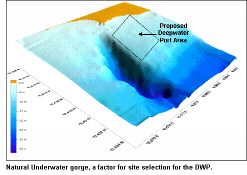
- Mapping and delineating the project area to be reclaimed which in the case of a deep water port , requires location of a natural underwater gorge or valley that will not require recurring maintenance dredging. This will serve as berthing area for ocean liners with large draught, while the island proper will be located adjacent the gorge on the underwater crest. Only survey methods can be used to determine seabed topography for accurate positioning of such projects. The proposed Sao Tome Deep Water Port project is a typical example. Creating artificial islands for tourism may not need such technicalities of locating naturally deep areas but rather shallow areas may be more economical to reclaim. The Dubai project “Dredging the world” consisting of creating artificial islands shaped after the continents, is a great engineering feat. Kudos must be given to the surveyors who set out those shapes in a marine environment.
- Geological survey of the sub-bottom for soil profiling is necessary to ensure a stable foundation and bearing capacity for the new island. Soil settlement or compaction trend is also determined by surveying methods.
- Locating the sand source and distance from such source to the construction site.
- Determination of vertical rise and fall and horizontal movement of water, current and wave analysis, to ensure that the island rises above the highest predictable flood level.
- Final perimeter and topographic survey of the completed island for planning of layouts depicting proposed road networks, buildings, utility lines on map sheets at appropriate scales.
BATHYMETRIC SURVEYS
This aspect of surveying involves depth sounding, determination of current speed and tidal range in a particular marine project area. This data is most relevant in most dredging jobs and underwater construction projects like bridges and dams. Production of pre and post dredge bathymetric charts along the channel for determination of shallow areas to be dredged, monitoring of dredging operation to ensure that specified channel depths and side slopes are eventually attained at the end of the project. Quantity determination of dredged material also requires pre and post dredge bathymetric data for volume computation. In beach nourishment and shoreline protection projects, determination of tidal Interval, current speed and direction are factors for determination of the hydrological circle and pressure the ocean surge exerts on the shoreline and subsequently the type of protection commensurate with such surge. In sand stockpiling, bathymetric data is essential around the borrow pits environment to ensure that the dredger can either sail smoothly or dredge a slot, to the sand pit.
SEABED SURVEYS
Sonar sweeping and production of seabed maps. This is an area that has been completely neglected by indigenous dredging outfits. The essence of which is to locate and depict on the map, natural and artificial obstacles lying on the seabed along the channel route. Obstacles such as wrecks, rocks, sunken trees and pipelines could cause impediments to dredging operations. The position of such underwater obstacles, if known, can either be avoided by choosing alternative routes or removed by salvage operations. A case of a dredger damaging an oil pipeline resulting in pollution is rather imagined than executed. This is why such data is relevant in dredging slots for underwater utility lines like oil pipelines, underwater cables and in construction of underwater tunnels..
MINING SURVEYS
Mining surveying is used to establish surface location and boundaries of mining claims. During mining or tunneling operations, the mine survey helps to establish the location of the underground workings horizontally and vertically, to lay out shaft connections, and to guide the tunneling. This is three-dimensional traversing, not essentially different from surface surveying. Underwater Mining entails locating the source of the mineral to be mined. This includes Sand, rocks, clay, gravel etc. The term ‘Sand Search’ simply implies exploring water bodies with the objective of locating areas with sand deposits in commercial quantity, to be exploited by dredging for reclamation of marshy terrain or stockpiling for sale to construction companies.
The importance of evaluating the status of the sub-bottom of water bodies in the dredging industry cannot be emphasized enough. Geological investigation of the substrata in and around dredging sites has been trivialized in Nigeria’s dredging industry and has resulted in some cases of failed projects due to faulty sand search reports among other factors. A good sand search survey report must among other things provide information as to the quantity of sand available for exploitation based on mathematical formulas not guess work ; the quality of sand, usually determined by laboratory sieve analysis for particle size range of the samples ; a coordinated bathymetric map of the project area , not a sketch, depicting depths for smooth navigation of the dredger to the sand pit and as a base for determining changes in the sub-bottom topography after dredging ; the exact co-ordinates of the center point and radius of burrow pits; the distances of the burrow pits to the stockpiling site and a recommendation on the length of dredger ladder required for maximum mining of the deposit from the burrow pits. Co-ordinates of underwater mining areas is also used by the Ministry of Solid Minerals and National Inland Waterways Authority for issuance of mining permits and licenses to intending entrepreneurs in the Sand Mining Business.
CONTRACTOR’S DESIGNING & ESTIMATION WITH RESPECT TO PRE-DREDGING AND SOIL INVESTIGATION.
Quoting for dredging projects by contractors require a large input of survey data, if under/over quoting is to be avoided. Consideration must be accorded the design and physical nature of the terrain among other factors, if proper estimates are to be arrived at. Answers must be provided for questions such as;
- What are the dimensions & area of the proposed project site?
- What is the geometrical shape?
- What is the true picture of the topography of the site?
- What type of topsoil is the site made of and will it be excavated before dumping?
- What quantity of material can the site contain as distinct from the contact quantity or will the site capacity determine the contract quantity?
- What are the distances from the points of exploitation to that of discharge?
- What ratio of floating and land pipes is adequate for the project?
- What quantity and quality of material is available underground for exploitation?
- Can the quantity and quality of material available in the underwater burrow pits be adequate to satisfy the demands of the site?
- What is the turbidity or mud content of the sub bottom?
- Is the mud thickness such that it can be an impediment to dredging?
- What is the right dredging equipment commensurate with such site condition?
- Is such an equipment available and at what cost?
- What is the draught of the dredger as compared with the bathymetry of the project site and its approach channel?
- Will it be smooth sailing to the project site or will there be the necessity to dredge some shallow areas for access and eventually dredge a slot to get to the burrow pit proper?
- Is the marine project environment free from wrecks, rocks, buried pipelines, underwater cables and other obstacles that could be an impediment to dredging operations?
- what is the diesel consumption & production rate of the dredger per hour (considering its water/solid material output ratio) and what quantity of diesel is needed to deliver the project quantity and at what duration?
- How many work shifts will be adequate to ensure that the contract quantity is delivered at the estimated time frame?
- What is the required human ( work force), financial ( cost of funds) and material resources ( dry plants, spare parts, contingencies etc) needed during the contract duration?
- What profit margin can be attained per cubic metre of material delivered and is it worth the time, resources and effort involved in achieving such profit margin.
The answers to these twenty questions have calculation components involving data acquisition or use of survey data, which are pre-requisites for arriving at true estimates to be used by the dredging contractor in the preparation of job quotations. Professional input in providing answers to these questions must be adhered to, especially as professional fees to be paid is far less than losses accruable to the contractor as a result of presentation of inadequate job estimates.
NEW UNDERWATER SEARCH EQUIPMENT FOR THE DREDGING INDUSTRY.
These include the following;
Side Scan Sonars : These are the best tools for underwater searches because they can cover large areas quickly and ‘see’ what is on the bottom regardless of water visibility. The printout ‘removes’ the water and shows a clear picture of the bottom. The picture is produced on a high resolution thermal printer that is built into the control unit. For every search carried out, a detailed copy of the sea floor will be produced for reference. Cost of Side Scan Sonar with Laptop PC and 17” thermal printer ranges between $25,000 to $30,000 depending on the operational frequency.
Metal Detectors: These are used for detecting all metals on land or underwater and comprises the hand-held models and the boat-towed models for deep waters. Its high sensitivity and pulse induction technology enables it to detect both ferrous and non-ferrous objects on or under the seabed. It has been used to locate and track underwater pipelines, find missing tools and dredge parts, locate weapons and unexploded ordinances and to search for lost treasure. Various models exist with cost ranging between $2,000 to $7,000 for hand-held units and $12,000 to $15,000 for boat-towed models.
Remotely Operated Vehicles: ROV’S are mobile underwater video systems that are remotely controlled form a survey vessel while the main unit does the underwater search. They are perfect for pipeline work, river and ocean searches and the inspection of hazardous sites thus eliminating the need to dive in difficult or dangerous waters. They are powerful enough to withstand currents and rugged enough to reach depths of 500 feet. With a proportionally controlled four-motor propulsion system which allows the vehicle to move in any direction while being monitored on an LCD color screen, its operation is very easy. Costs range is between $25,000 to $35,000 depending on the model while depth range is up to 1000 feet.
Underwater Cameras: These are very useful in inspection of underwater pipe leakages, dredger ladders stuck underwater and bottom plate leakages in shallow waters. There are the hand-held types used by divers and come in various models including the DHC-1 Diver held Video Camera and lightening system and the MC-1 Mini Camera. Cost range is between $1000 and $2,500.
Sub-Bottom Profilers These are specialized electronic survey equipment used primarily for detecting the soil profile of designated areas below the seabed. Attached with a portable printer uses acoustic technology to penetrate the seabed up to 100 metres or more and automatically displays the seabed profile on its screen while printing hard copies for reference. They are acknowledged as the proper equipment for sand search in dredging operations. Cost range between 50,000 to 65,000 euro for the protable models and 150,000 to 200,000 euro for the higher grade models used in exploration geophysics in the oil industry..
ENVIRONMENTAL IMPACT ASSESSMENT SURVEY TECHNIQUE IN DREDGING.
The Federal Republic of Nigeria, judging from its rather unpalatable experience from the exploration, exploitation and refining of petroleum products especially in the Niger Delta Area has resolved to give environmental issues in project implementation a priority concern. Legislations like Government Harmful Waste Disposal Decree No. 42 of 1988 and the National Policy on the Environment with the Federal Environmental Protection Agency (FEPA) backed by Decree No. 58 of 1988, to enforce environmental protection regulations, had been put in place.
The environmental impact of dredging revolves mainly around land and marine disposal of dredged materials. The immediate impacts of land disposal of dredge spoils includes
- Changes in the topography of the site and the composition of the surface layer of the disposal ground.
- Air pollution and odour which may be harmful to humans
- Pollution of the water table
- The destruction of fauna and flora
- Impaired visual quality.
The effects of disposing dredged material in open waters may be temporary or permanent. Permanent impacts include;
- Changes in the bottom morphology and alterations in the nature of the materials constituting the upper layer of the bottom surface.
- Destruction and disturbance of flora and fauna.
Temporary impacts include;
- Turbidity
- Degradation of water quality at the disposal site
- Pollution and discoloration of beaches and other recreational areas.
The imposition of restrictions on disposal of dredge materials in open waters is due to the impact of such disposal on the marine environment. In particular are contaminated or polluted materials, which have led to placement of such materials in designated containment facilities or not permitting dredging at all. The list of potential contaminants is very long but include trace metals, bacteria, petroleum hydrocarbons and man-made organic compounds. Pollution occurs when the concentrations of various chemical or biological constituents exceed a level at which a negative impact on amenities, the ecosystem, resources and human health can occur. Thus it is very important in the planning of dredging projects to carefully characterize and describe the nature of material to be dredged, not just in an overall sense but location by location and at sediments which are truly contaminated that require special handling and those which are a little different from natural sediments in the region and could therefore be disposed at open water sites. Significant financial savings can be obtained by not having to contain or handle in a special fashion all of the dredged materials. A special purpose map prepared by a surveyor can give a bird’s eye view of such data as an essential tool in pre-dredge project planning and eventual implementation.
John Chukwuma, a surveyor delivered this paper at the Nigerian Dredging Summit 2007 held at Protea Hotel, Lekki Lagos Nigeria on the 8 th & 9 th of Nov. 2007.